In 2026, the Bermuda Triangle looks far less mysterious than its reputation suggests. Modern data points to weather, fast currents, heavy traffic, and human error—not supernatural forces. Some cases remain uncertain, but the evidence favors ordinary risks in a busy, unforgiving stretch of ocean.
The Latest Theories Explained
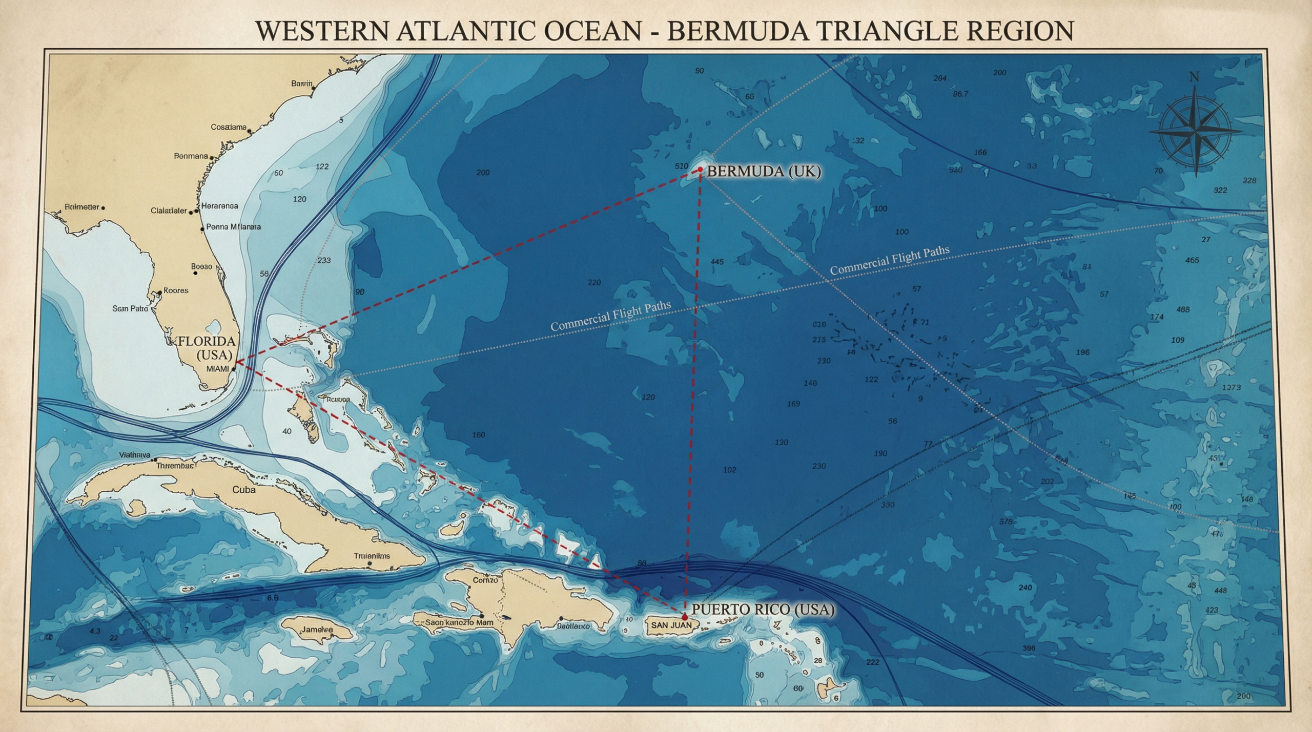
The Bermuda Triangle sits in a wide stretch of the western Atlantic, roughly connecting Florida, Bermuda, and Puerto Rico. It’s not a place you can point to on an official map, but it’s a place people still talk about like it has borders, rules, and a personality.
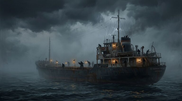
The story is familiar: planes disappear, ships never return, radios go quiet. It feels personal because the Triangle is close to major US coastlines and popular travel routes. When something goes wrong there, it can sound like the ocean swallowed the evidence.
But the most consistent takeaway from modern investigations is simple and a little less cinematic. Current research and long-running reviews by aviation and maritime authorities point to weather, ocean conditions, traffic volume, and human factors, not anything supernatural. In a corridor this busy, even normal accident rates generate a lot of headlines, and legends thrive in the gaps.
Start with the basics: what the Bermuda Triangle is, and what the numbers actually show
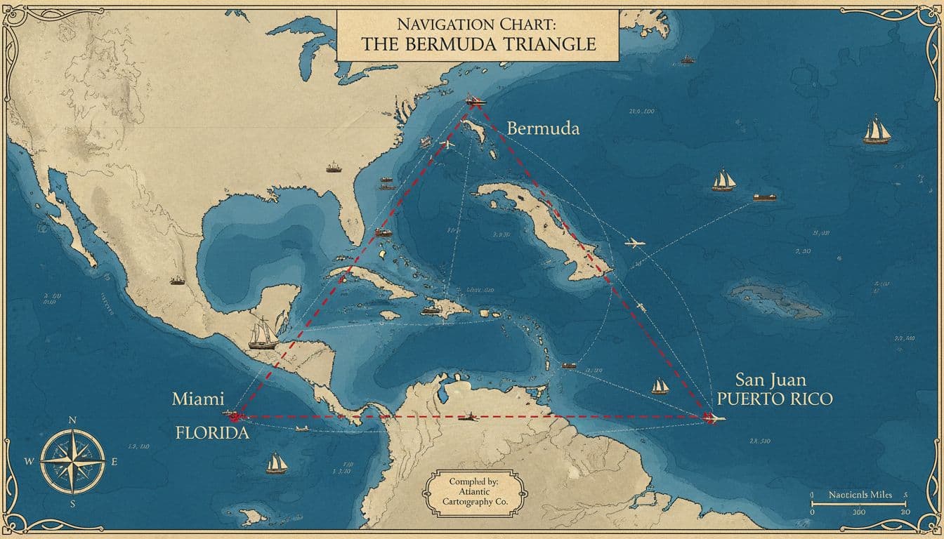
The first thing to know is that the Bermuda Triangle isn’t an official zone. There’s no international body that defines its edges, and different books and documentaries draw it differently. Most versions still circle the same general area between Florida, Bermuda, and Puerto Rico, but the “triangle” shape is more traditional than measurement.
That matters because definitions shape statistics. If the borders shift depending on the storyteller, the list of “Triangle cases” shifts too.
Insurers and investigators have also pushed back on the idea that the region is uniquely deadly. Reviews often cited in mainstream reporting say the loss rate is not higher than other heavily traveled ocean regions, especially when you account for how many flights and voyages pass through. In other words, the Triangle can feel unusually dangerous because people count the stories, not the traffic.
A grounded summary of why the legend doesn’t match the data appears in coverage like BBC Science Focus’s explainer, which argues the “mystery” shrinks once you focus on weather, geography, and reporting habits rather than folklore (see how science approaches Bermuda Triangle claims).
A busy route plus hard-to-search water can look like a mystery
This part is easy to underestimate. The Triangle overlaps with major shipping lanes, cruise routes, and flight paths. High traffic means more things can go wrong, even if the odds per trip stay normal.
Search-and-rescue is also harder than people imagine. Storms can build quickly, and the ocean can hide evidence fast. If a plane goes down far offshore, depth becomes a problem. If a ship founders in rough weather, debris can scatter or sink. In older cases, records were thinner, and communications were less reliable, leaving space for later retellings to grow.
What “vanished without a trace” often means in real investigations
“Without a trace” doesn’t usually mean nothing existed. It often means investigators had limited wreckage, no clear distress call, or no confirmed final position. Time works against every search. The longer the delay, the farther floating debris can drift, and the more likely delicate evidence is destroyed.
Depth is another factor. Large areas of the Atlantic drop quickly, and not every search can put sonar and submersibles on every square mile. Add currents and storms, and the absence of evidence can look like a clean disappearance, even when the most likely explanation is a fast, fatal accident.
Natural forces that can overwhelm ships and planes in minutes
People sometimes talk about the Bermuda Triangle as if it has one secret cause. In reality, the strongest explanations are ordinary hazards that become scary when they overlap: powerful storms, complex seas, and a current system that moves like a conveyor belt.
The important nuance is this: none of these forces is unique to the Triangle. The difference lies in the mix of conditions and the volume of traffic passing through. When bad weather meets a busy corridor, you get more near-misses and some tragedies. Those stories get repeated, simplified, and turned into a pattern.
Rogue waves, when storms collide and the sea spikes without warning
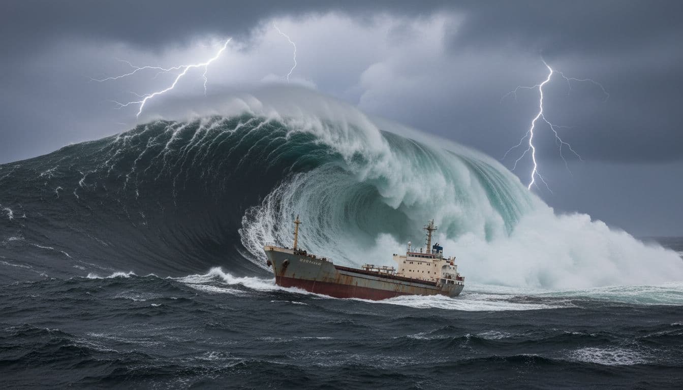
A rogue wave isn’t a myth wave. It’s a real ocean phenomenon: a wave much larger than the surrounding sea state, rising abruptly and carrying a huge force.
Researchers have described how storms approaching from different directions can pile energy into the same patch of water. Oceanographer Simon Boxall and others have discussed modeling that shows that converging systems can produce rare waves around 30 meters (about 100 feet) in height. A wall of water like that can overwhelm even large ships, especially if it hits at the wrong angle or arrives as a set.
This doesn’t prove any specific Bermuda Triangle disappearance was caused by a rogue wave. Cases often lack the direct measurements you’d need. It shows a simple truth: the ocean can generate a strike that appears sudden, violent, and final.
Microbursts and “hexagon” cloud patterns are tied to sudden, violent winds
A microburst is a burst of air that falls from a thunderstorm and slams into the surface, spreading outward in a straight-line blast. Pilots fear microbursts because wind direction and speed can change quickly near the surface. Mariners fear them because they can kick up steep, messy seas in minutes.
Some satellite images have shown hexagon-shaped cloud patterns over ocean areas, including regions associated with the Bermuda Triangle legend. The cautious interpretation is that certain cloud shapes can line up with intense storm dynamics that produce strong downdrafts and gust fronts. Under the right conditions, those winds can push seas into short, sharp waves that are hard to ride out.
It’s tempting to treat the cloud shape as a signature of danger. It isn’t. Clouds don’t “cause” disappearances by themselves. There are clues that the atmosphere is behaving in ways that could quickly turn routine travel into a survival problem.
The Gulf Stream is fast water that can move debris far from the last known point
The Gulf Stream is a strong, warm current that runs up from the Gulf of Mexico, past Florida, and into the Atlantic. It can be an engine for weather and a headache for searches.
If an accident occurs and debris floats, the Gulf Stream can carry it away from the last reported position. That alone can create the impression of a clean vanish. Even when a wreck site exists, surface evidence may drift far before search teams arrive.
In older cases, this matters even more. Position reports were sometimes rough, and communication could break down under stress. Put fast currents on top of uncertain coordinates, and you get a wide search area with few obvious clues.
For a mainstream summary of the “ordinary hazards” view, Popular Mechanics has covered how probabilities, storms, and human decisions explain much of the Triangle’s reputation (see Popular Mechanics on the Bermuda Triangle debate).
Human and tech factors that turn a bad day into a disaster
Even with today’s forecasting and tracking, the most common ingredient in accidents is still human decision-making under pressure. That’s not an insult. It’s a reality of work that takes place in shifting weather, over long distances, with fatigue and limited margins for error.
Historically, aviation and shipping through the area included periods when equipment was less precise, and weather information was less detailed. Before GPS, crews relied more on compass headings, dead reckoning, radio navigation aids, and celestial fixes. Each system can work well, but each has failure modes, especially when stress rises and the environment gets loud.
And then there’s the part people hate to hear: many incidents aren’t “one big mistake.” They’re a chain of small ones. A heading slightly off. A storm line was underestimated. A fuel calculation that assumes ideal winds. A decision to press on rather than turn back.
Compass confusion near the agonic line, small errors that can snowball
Compasses don’t point to “true north.” They point to magnetic north, and the difference between the two changes by location and over time. In some places, that difference is big enough to matter a lot. In a few places, the difference can be close to zero. The Bermuda Triangle is often mentioned because an agonic line (where true north and magnetic north align) passes through the broader region at times.
That alignment can sound like a magic trick, but it’s really a reminder that navigation requires context. If a crew expects a certain magnetic variation and doesn’t account for the local value, a heading can be off. Over a long flight or voyage, that error can grow into real trouble, especially if weather forces detours.
Good practice is boring: cross-check instruments, confirm position often, and don’t treat any single gauge as a truth machine.
| Myth | Reality |
|---|---|
| Ships and planes vanish without explanation. | Most incidents are explained by weather, navigation challenges, or human decisions under pressure. |
| The Bermuda Triangle is an officially recognized danger zone. | It has no formal boundaries and is not recognized by maritime or aviation authorities. |
| Compasses behave strangely only in this region. | Magnetic variation occurs worldwide and must always be accounted for in navigation. |
| Rogue waves and sudden storms are myths. | These are real, well-documented phenomena capable of overwhelming ships and aircraft. |
| Aliens, Atlantis, or time distortions are responsible. | No measurable evidence supports these ideas. They persist as stories, not documented causes. |
Famous cases like Flight 19, why “mystery” often starts with confusion and weather
Flight 19 (1945) is one of the most cited Bermuda Triangle stories. The reason it stays in the public mind is that it involved experienced military aircraft on a training mission, followed by confusing communications and a loss that was difficult to pin down.
It’s also a useful example of how “mystery” can form from ordinary pressures. Reports and later summaries point toward navigation uncertainty, worsening weather, and compounding decisions. In that era, crews didn’t have GPS or modern radar weather views. If you’re unsure of your position and conditions are deteriorating, even a disciplined plan can unravel fast.
It’s important to be careful with the details here because retellings can inflate or simplify what’s known. The larger lesson holds without dramatics: when situational awareness breaks down, the sea and sky don’t give you much time to recover.
The latest theories people still share, and what the evidence says now
The Bermuda Triangle has always been a magnet for big explanations. Some of them borrow real science terms. Others lean into lost civilizations or UFO lore. They stick around because they offer neat answers to messy events.
A more responsible way to handle these ideas is to separate three things:
- What the claim says
- Whether physics is possible in general
- Whether the evidence fits the Bermuda Triangle, right now
Methane hydrate “burps”, possible physics, weak support for recent events here
Methane hydrates are ice-like deposits that can hold methane in seafloor sediments. The core idea behind the “methane burp” theory is buoyancy: if a large amount of gas is released into the water column, the water becomes less dense, and a ship could lose lift and sink faster than expected.
As physics, it’s not nonsense. Gas in water can reduce buoyancy. The problem is the step people skip: evidence of recent, massive releases in the Bermuda Triangle.
Based on the geological timeline often cited in skeptical reviews, there’s no strong indication of the kind of giant blowouts needed to explain modern disappearances, with some researchers noting no such major event in the area for roughly 15,000 years. That doesn’t mean methane hydrates don’t exist. This explanation is a weak match for the modern legend.
News coverage that leans on probability and ordinary causes, sometimes quoting science communicators like Karl Kruszelnicki, reflects where the broad consensus sits (see reporting on probability and weather factors).
Atlantis, aliens, and “time fog”- why these stories spread even without proof
Three popular claims come up again and again:
Atlantis tech: The idea that a lost civilization left energy sources that interfere with instruments. There’s no testable evidence for this in Bermuda Triangle investigations, and no verified artifacts tied to such a mechanism.
Alien abductions or portals: Usually framed as a gateway that “takes” ships and planes. These claims don’t come with consistent data, measurable traces, or repeatable patterns. They also don’t explain why the region’s loss rates align with other busy ocean areas when you look at broad trends.
Electronic fog or time slips: Often linked to personal stories, including accounts of odd cloud banks and confusing time estimates. Humans misjudge time and distance easily under stress, and older aircraft had fewer tools to confirm ground speed and position in real time. Without instrument logs and corroborating data, these stories remain anecdotes, not evidence.
None of this is meant to mock people who grew up hearing the legend. It’s just the standard used in serious investigations: claims have to be measurable, repeatable, and supported by records.
A grounded takeaway for the Bermuda Triangle in 2026
The Bermuda Triangle remains a powerful story because it sits at the intersection of real danger and missing information. But the best-supported explanations are the plain ones: severe weather, rogue waves, microbursts, fast currents like the Gulf Stream, and human errors that stack up when conditions get bad.
Some older cases will stay uncertain. Records can be incomplete, and the ocean is an expert at erasing scenes. That uncertainty doesn’t point to the supernatural; it points to the limits of evidence.
Modern tracking, forecasting, and safety rules reduce risk, even in rough water. They don’t make the region harmless. The most honest way to think about the Bermuda Triangle is as a busy, sometimes hostile stretch of Atlantic, where nature and human limits can collide, fast.
Key Takeaway
The Bermuda Triangle doesn’t hold up as a supernatural danger zone in 2026. When traffic volume, weather systems, ocean currents, and human decision-making are accounted for, the mystery shrinks fast. What remains isn’t a secret force, but a busy stretch of ocean where ordinary risks sometimes stack up in unforgiving ways.
Bermuda Triangle FAQ
Is the Bermuda Triangle an officially recognized location?
No. The Bermuda Triangle has no formal boundaries or recognition by maritime or aviation authorities. Its shape and size change depending on who is describing it.
Do ships and planes disappear there more often than elsewhere?
Available data does not show higher loss rates compared to other heavily traveled ocean regions. The area feels more dangerous mainly because traffic volume is high and incidents get repeated in retellings.
What causes most Bermuda Triangle incidents?
Severe weather, fast-moving currents like the Gulf Stream, navigation challenges, and human decision-making explain most cases without requiring supernatural explanations.
Is there any evidence for aliens, Atlantis, or time distortions?
No credible evidence supports those ideas. They persist as stories, not because of measurable data or verified physical effects tied to the region.